Maritiem Digitaal
collectie zoeksyteem van de maritieme musea
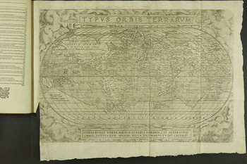
Kaart van de wereld


| titel | Kaart van de wereld |
|---|---|
| inventarisnummer | BWAE193-P2 |
| collectie | cartografie |
| museum | Maritiem Museum Rotterdam
|
| maker | Ortelius, Abraham; Bishop, George; Newberie |
| scheepsnaam | wereld[aarde] |
| omschrijving | Kaart opgenomen in de uitgave The Principall Navigations, Voiages and Discoveries of the English nation, made by Sea or over Land, to the most remote and farthest distant quarters of the earth at any time within the compasse of these 1500 yeeres: Devided into three severall parts, according to the regions wherunto they were directed.The first, conteining the personall travels of the English unto Iudaea, Syria, Arabia, the river Euphrates, Babylon, Balsara, The Persian Gulfe, Ormuz, Chaul, Goa, India, and many Islands adioyning the South parts of Asia: together with the like unto Egypt, the chiefest ports and places of Africa with in and without the Streight of Gibraltar, and about the famous Promontorie of Buona Esperanza ... Uitgegeven in 1589 te Londen door George Bishop en Ralph Newberie. De cartograaf is Abraham Ortelius, die leefde van 1527 tot 1598. Te zien is de wereld door wolken omringd. De kaart in dit boek is van latere druk en dus later toegevoegd. Volgens Rodney Shirley, auteur van The mapping of the world, werd in de negentiende eeuw door Henry Stevens een facsimile uitgegeven van de Ortelius kaart en is deze soms in orginele versies van Hakluyt's boek te vinden. Eenzelfde kaart is ook opgenomen in de Engelse editie van Jan Huygen van Linschoten's Itinerario ..., uitgegeven in 1598. |
| afmetingen | hoogte 33 cm breedte 48 cm hoogte 33.5 cm breedte 72.5 cm |
| startdatum | 1589 |
| einddatum | 1589 |
Bekijk ook

website: Trilobiet ID


Commentaar van bezoekers