Maritiem Digitaal
collectie zoeksyteem van de maritieme musea
zoekresultaten
zoekvraag: maker = Seller, John
aantal treffers: 48
| titel | type | museum | afbeelding |
|---|
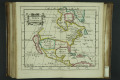
| 41 | BWAE150-P33
North America |  | 
Maritiem Museum Rotterdam | |
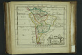
| 42 | BWAE150-P34
South America | |
Maritiem Museum Rotterdam | |
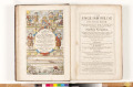
| 43 | S.4793(704)
Practical Navigation : Or, An Introduction to the Whole Art : Containing many useful Geometrical Definitions and Problems : The Doctrine of Plain and Spherical Triangles : [...] sundry useful Problems in Astronomy : The Use of Instruments [...] Useful Tables [...] Also a Table of 10000 Logarithms, a... |  | 
Het Scheepvaartmuseum | |
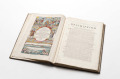
| 44 | S.4793(729)
Practical Navigation : Or, An Introduction to the Whole Art : Containing The Doctrine of Plain and Spherical Tri-angles : Plain, Mercator, Great-circle Sailing : and Astronomical Problems : The Use of divers Instruments : as al-so of the Plain-chart, Mercator's Chart and both Globes, Sundry Useful T... | |
Het Scheepvaartmuseum | |
| 45 | WAE112
The English pilot: Describing The Sea-Coasts, Capes, Head-lands, Soundings, Sands, Shoals, Rocks and Dangers ; ...... by John Seller ... London, printed by John Darby, at the sign of the Mariners-Compass, at the Hermitage-stairs in Wapping: and by John Wingfield, stationer, right against St.Olaves C... | |
Maritiem Museum Rotterdam | |
| 46 | WAE113
Atlas maritimus or a book of charts decribeing of the sea coasts ... of the world ... by John Seller ... in London | |
Maritiem Museum Rotterdam | |
| 47 | WAE114
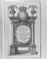
ATLAS MARITIMUS or a book of charts. Describeing the SEA Coasts Capes Headlands Sands Shoals Rocks and Dangers. the Bayes Roads Harbors Rivers and Ports. in most of the knowne parts of the World. With the true Courses and distances, from one place to another, Gathered from the latest and best Discov... | |
Maritiem Museum Rotterdam | |
| 48 | WAE114-11
Plattegrond van Tripoli, 1675A Mapp of the Citie and Port of Tripoli in Barbary. W. Hollar fecit, 1675. | |
Maritiem Museum Rotterdam | |