| 1 |
1688 : the seaborne alliance and diplomatic revolution : proceedings of an international symposium held at the National Maritime Museum, Greenwich, 5-6 October 1988 |  | 
Maritiem Museum Rotterdam | |
| 2 | 1989.0669/S.8030
1688 : The seaborne alliance and diplomatic revolution : proceedings of an international symposium held at the National Maritime Museum, Greenwich 5 - 6 October 1988 | | 
Het Scheepvaartmuseum | |
| 3 | 1998.3443
Kaart van de wateren van de Indonesische Archipel en westelijk Nieuw Guinea. [...] |  |
Het Scheepvaartmuseum | |
| 4 | 28333
Harwich and the Continent | |
Maritiem Museum Rotterdam | |
| 5 | K1323
A chart of the English Channel, & c. (middelste deel van grote kaart) | |
Maritiem Museum Rotterdam | |
| 6 | K1324
A chart of the English Channel, & c. (linker deel van grote kaart) | |
Maritiem Museum Rotterdam | |
| 7 | K1325
England and Holland, &c. From Beachy Head to the River Humber, and from Boulogne to the Texel. | |
Maritiem Museum Rotterdam | |
| 8 | K1326
England and Holland, &c. From Beachy Head to the River Humber, and from Boulogne to the Texel. | |
Maritiem Museum Rotterdam | |
| 9 | K1335
Coasts of Great-Britain, Ireland, France, Spain, Portugal, & c., showing the whole navigation from the Feroe and Orkney Isles to Gibraltar, Barcelona, Algiers &c. | |
Maritiem Museum Rotterdam | |
| 10 | K1353
A chart of the Cape Verde Islands, drawn from the latest authoroties by J.W. Norie, hydrographer | |
Maritiem Museum Rotterdam | |
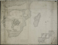
| 11 | K1363
Coast of the Cape Colony, Delagoa Bay & c., Madagascar, Bourbon, Mauritius &c. | |
Maritiem Museum Rotterdam | |
| 12 | K1370
The Island of Rodrigues - Plan of Port Louis - Isle of France or Mauritius - Plan of Port Bourbon with its entrances - The Island of Bourbon, or Ile de la Réunion. | |
Maritiem Museum Rotterdam | |
| 13 | K1375
China Sea. Singapore, Banka, Gaspar, & Sunda Straits. | |
Maritiem Museum Rotterdam | |
| 14 | K1378
A chart showing the navigation through the Strait of Malacca, to Singapore, &c. | |
Maritiem Museum Rotterdam | |
| 15 | K1382
The lower part of the China Sea | |
Maritiem Museum Rotterdam | |
| 16 | K1384
Chart of the China Sea in two parts | |
Maritiem Museum Rotterdam | |
| 17 | K1386
A general Chart of the Indian and part of the Pacific Oceans showing the various passages to & from China, Australia's, New Zealand, &c. Carefully constructed & Compiled from the most approved observations and modern surveys, by J.S. Hobbs , F.R.G.S. Hydrographer 1850. London published as the Ac... | |
Maritiem Museum Rotterdam | |
| 18 | K1387
The eastern coast of Australia, with part of the Pacific Ocean | |
Maritiem Museum Rotterdam | |
| 19 | K5569
The southern or lower part of the Pacific Ocean with additions 1854 | |
Maritiem Museum Rotterdam | |
| 20 | K5570
Chart of the West Coast of South America from Truxillo to Panama including the Galapogos Island with plans of the principal harbours chiefly from the late English surveys [...] | |
Maritiem Museum Rotterdam | |