Maritiem Digitaal
collectie zoeksyteem van de maritieme musea
zoekresultaten
zoekvraag: scheepsnaam = Ierland[eiland]
aantal treffers: 26
| titel | type | museum | afbeelding |
|---|
| 21 | K5587
Kaart van de Noord-, West- en Zuidkust van IerlandA chart of the North, West and South Coasts of Ireland, from Bengore Head to the Saltee Islands: with enlarged plans of the principal Harbours, Roadsteds, &c. Construted & Drwan from the most approved Observations and Surveys, by J.S. Hobbs, Hydrogra... |  | 
Maritiem Museum Rotterdam | |
| 22 | K5588
Kaart van St George's Channel (St George Kanaal) en het Bristol Channel (Bristol Kanaal)A chart of St George's & Bristol Channels. Constructed & Drawn from the latest Observations & Surveys, with plans of Liverpool, Holyhead, Carlingford, Ardclass, Larne, Campbleton, the Cluyde & Lanlash | |
Maritiem Museum Rotterdam | |
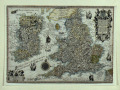
| 23 | WAE49_90
Kaart van de Britse Eilanden door Johannes Janssonius, ca 1638.Magnae Britanniae et Hiberniae Nova Descriptio. | |
Maritiem Museum Rotterdam | |
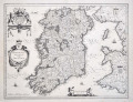
| 24 | WAE49_92
Kaart van Ierland door Johannes Janssonius, ca 1636.Hibernia Regnum Vulgo Ireland. | |
Maritiem Museum Rotterdam | |
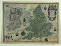
| 25 | WAE692
Kaart van Engeland, Wales en Ierland door Cornelis Claesz, 1592Anglia insulae Brittaniae pars.. Hibernia,.. | |
Maritiem Museum Rotterdam | |
| 26 | WAE693
Kaart van Engeland, Wales en Ierland door Cornelis Claesz, 1592Anglia insulae Britanniae...Hibernia... | |
Maritiem Museum Rotterdam | |